By: Drew M. Widders, Esq., of Wilcoxen Callaham, LLP, and CCTLA Board Member
This article discusses the use of e-discovery and drone technology in a crop loss case that Dan Wilcoxen and I recently resolved to our satisfaction.
The case involved our clients’ large almond orchard mistakenly being sprayed by an aerial applicator with Chateau herbicide (a weed killer) as opposed to what was supposed to be sprayed, Quash fungicide (a chemical designed to protect trees). The weed killer all but destroyed the almond crop we estimated to be valued at $1.3 million. We claimed it also caused long- term damage to the almond trees.
The co-op also stated that since our clients’ family had been members in the co-op since 1978, they could be confident the co-op would not turn their back on them. The co-op agreed to supply our clients with ag chemicals until they were made whole. The co-op also said it would work on getting our clients a cash advance so they could invest the money into planting additional almond trees which would more than double their almond orchard.
All that changed when the co-op learned that the $15-mil- lion excess policy it had purchased contained an exclusion for any and all liability from damages due to herbicides, pesticides and fungicides. Thereafter, co-op employees and experts disput- ed our clients’ farming abilities and the productivity and quality of the almond orchard before the application. No cash advance was provided. Then, the co-op asserted a crop-lien against the almond orchard’s next year crop.
When that attempt was unsuccessful, the co-op cross- claimed against our clients for the ag chemicals they were supposed to be giving them and added interest at 18 percent per year. The co-op’s alleged cross-claim had grown to approxi- mately $425,000 by time of the settlement conference. Our cli- ents were then kicked out of the co-op for allegedly not paying for the agricultural chemicals that made up the cross-claim.
Employing an E-Discovery Expert
During discovery in this case, there were issues over the emails relating to the events which were produced by the co-op. We repeatedly requested all emails in discovery requests. The response was always that all emails had already been produced. At that time, we only had about six emails produced in discovery. After a former employee claimed in his deposition that he had additional emails, we decided to have the co-op’s computers forensically examined by an e-discovery expert.
I did an article concerning electronically stored information for the Litigator in June/July 2017 that can be found at https:// cctla.com/wp-content/uploads/2017/05/summer-2017.pdf. This was the first time, however, that we employed the e-discovery expert mentioned in that article to forensically examine the other sides’ computers for relevant documents. This was a very costly and time-consuming endeavor; however, it turned out to be worth it.
After motions, numerous delays and just one month before trial, we received thousands of pages of documents not previ- ously produced. We found emails that undermined the basis for the claimed $425,000 cross-claim. Other emails helped prove our lost investment opportunity claim of $1,000,000 that the defendants werefiling a motion in limine to eliminate as too speculative. Weeven found an email that detailed the real reasons our clients were kicked out of the co-op. We found, in the right case, employing an e-discovery expert can be a very effective discovery tool.
Drone Mapping
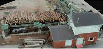
Another interesting tool we used in this case was drone mapping. Drone technology gets more advanced every year. A drone can be used to create accurate overviews and 3-D models of site locations. The drone itself takes 100’s-1000’s of aerial pictures of a site location. These pictures are then combined to create the overviews and 3-D models.
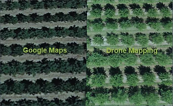
In addition to giving a much higher level of detail than Google Maps, the 3D models can also give accurate heights, widths and distances between objects. Drone technology is already being employed at great cost savings by insurance com- panies for property valuations and damage assessments. Rather than having someone measure distances and assess damages in person, the insurance companies use drones to create a 3D model of a site location that they can then view on a computer, take measurements and assess damages remotely. In this case, while we had Google Maps images of the almond orchard, the detail was limited. We used the company Lightspeed Sensing and Consulting Modeling to deploy a drone to recreate the almond orchard and combine it with Google Maps, but in much greater detail. You can see the difference below:
In addition to the more detailed Google Maps view above, the 3-D mapping feature can create an accurate 3D model of a scene location. Below is an example of a logging site recreated in 3D with drone pictures. You can take measurements, zoom in and out and look at the scene from various viewpoints:
